


Singaraja is the capital of the regency of Buleleng, which covers the north side of the island of Bali. Buleleng is the largest province of Bali in terms of area. During the colonial period, Singaraja was the capital of Bali and the Lesser Sunda Islands; in 1953 the capital was moved to Denpasar in the south. During the colonial period, the harbor in Singaraja was the entry point to the island for visitors and a variety of goods including slaves and opium.
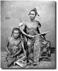
Raja of Buleleng and his secretary circa 1875. Image:
Tropenmuseum of the Royal Tropical Institute
Buleleng was founded on March 30, 1604, by the legendary Gusti Panji Sakti who was descended from the son of Dalem Sagening, king of Gelgel, and who at one time ruled both Buleleng and Blambangan in Java. The story goes that Panji Sakti left Klungkung to found a new kingdom in North Bali. When Panji Sakti reached the top of the mountain range, he was thirsty, but there was no water. So, he drove his magic kris into the ground and a spring formed. This spring still exists today at the site of the Pura Yeh Ketipat temple in the Lake Beratan area. Eventually Panji Sakti built three palaces; the last palace was at the site of Singaraja and this is considered the official birth date (1604) of the city and the kingdom of Buleleng.
Buleleng was the first of the Balinese kingdoms to fall to the Dutch after three battles in 1846, 1848 and 1849. (I’ll have more about this in my posts about the Bugis in Kampung Bugis.) Buleleng has 9 kecamatans (sub-districts); these are Gerokgak, Seririt, Busung Biu, Banjar, Buleleng, Sukasada, Sawan, Kubutambahan and Tejakula. Geographically Buleleng includes mountain ranges in the south, two lakes in the mountains and the relatively narrow coastal plane that skirts the Bali Sea on the north. Agriculture, manufacturing, tourism and crafts are the main areas of the economy. The regency’s land area is 24.25% of the total land area of Bali. Buleleng’s has a varied climate; the mountain ranges to the south regularly receive rainfall, while the coastal area has a dry season and a wet season.
According to the Kabupaten Buleleng’s website, the regency (or district as it is sometimes called) had a population of 786,972 in 2009. While the sub-district of Buleleng has the smallest area of the nine sub-districts, it has the largest population and highest population density. The sub-district of Buleleng had a population of 146,942 with a density of 1,515 people per square kilometer; the city of Singaraja has somewhere between 80,000 to 100,000 residents and this accounts for the high population density of Buleleng. Singaraja is known as a city of education.
Kampung Bugis is located right along the Bali Sea (sometimes also called the Java Sea or the Bali/Java Sea), and is adjacent to the harbor. The total area of Kampung Bugis is 30 hectares. In addition to having the sea as its northern border, it borders Kampung Baru to the east, Kampung Kajanan to the south and Kampung Anyar to the west. The kampung has 3,299 residents, divided almost equally between males and females. Trading is the most common occupation, and there are 21 residents listed as making their livelihood by fishing.
