Sheikhupura Fort, Pakistan: A Trip Back in Time

swimmers

I’m going to take a brief break today from my walking tour of Singaraja and journey back to Pakistan where I spent four intense, memorable and rewarding years. One of my teaching responsibilities during the first two years of my teaching in Lahore was a high school anthropology class. Those two years were the only time that I taught an anthropology class to students below university level, so it was a bit of a challenge. But, I had the opportunity to take two of my classes outside the school for field trips around Pakistan. The first trip included a visit to an old fort in the town of Sheikhupura which is jus 35 miles northwest of Lahore.

raja2

The city origins date back to 100 BC. Sheikhupura takes its name from the nickname for the Mughal Emperor Jahangir. Alexander the Great supposedly fought a battle here. The city was a focal point for struggles between Muslims and Sikhs for control of the area. The Sikhs eventually won out and held the city until they were defeated by the British sometime around 1850. Sheikhupura became part of Pakistan after Partition. Until then, the city was a mix of Hindu, Muslim and Sikh residents.

manwoman

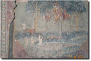
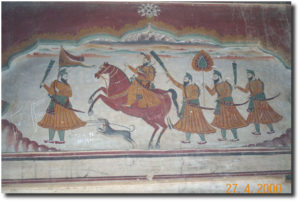
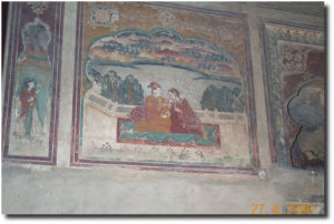
It seems uncertain exactly when Sheikhupura Fort was constructed. One argument is that it was built in 1619 for use as a hunting lodge. It is generally accepted that the fort was built by Emperor Jahangir sometime after 1607 and was used as a camp for the Emperor when he was in the area, usually for hunting. Later the fort was used as a home for the Sikh Princess Rani Nikayan; this accounts for many of the lovely frescoes still in existence (although some have been defaced by vandals) of dancing girls, court scenes, wildlife and images of Guru Nanak. The Asian Historical Architecture has an excellent section on Sheikhupura Fort including interior maps and 90 photos. I love this site because I lost most of the photos that I took during our field trip.

According to a news report from 2010, the United States was contributing $850,000 to the cost of renovating the fort. I was looking for some more recent information on the renovation project, but I haven’t been able to find any. This is one of the many places that I would enjoy visiting should I be fortunate enough to return to Pakistan one day.

A Brief Historical and Socioeconomic View of Buleleng, Singaraja and Kampung Bugis

Singaraja is the capital of the regency of Buleleng, which covers the north side of the island of Bali. Buleleng is the largest province of Bali in terms of area. During the colonial period, Singaraja was the capital of Bali and the Lesser Sunda Islands; in 1953 the capital was moved to Denpasar in the south. During the colonial period, the harbor in Singaraja was the entry point to the island for visitors and a variety of goods including slaves and opium.

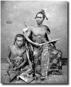
Raja of Buleleng and his secretary circa 1875. Image:  Tropenmuseum of the Royal Tropical Institute

Raja of Buleleng and his secretary circa 1875. Image:
Tropenmuseum of the Royal Tropical Institute

Buleleng was founded on March 30, 1604, by the legendary Gusti Panji Sakti who was descended from the son of Dalem Sagening, king of Gelgel, and who at one time ruled both Buleleng and Blambangan in Java. The story goes that Panji Sakti left Klungkung to found a new kingdom in North Bali. When Panji Sakti reached the top of the mountain range, he was thirsty, but there was no water. So, he drove his magic kris into the ground and a spring formed. This spring still exists today at the site of the Pura Yeh Ketipat temple in the Lake Beratan area. Eventually Panji Sakti built three palaces; the last palace was at the site of Singaraja and this is considered the official birth date (1604) of the city and the kingdom of Buleleng.

Buleleng was the first of the Balinese kingdoms to fall to the Dutch after three battles in 1846, 1848 and 1849. (I’ll have more about this in my posts about the Bugis in Kampung Bugis.) Buleleng has 9 kecamatans (sub-districts); these are Gerokgak, Seririt, Busung Biu, Banjar, Buleleng, Sukasada, Sawan, Kubutambahan and Tejakula. Geographically Buleleng includes mountain ranges in the south, two lakes in the mountains and the relatively narrow coastal plane that skirts the Bali Sea on the north. Agriculture, manufacturing, tourism and crafts are the main areas of the economy. The regency’s land area is 24.25% of the total land area of Bali. Buleleng’s has a varied climate; the mountain ranges to the south regularly receive rainfall, while the coastal area has a dry season and a wet season.

According to the Kabupaten Buleleng’s website, the regency (or district as it is sometimes called) had a population of 786,972 in 2009. While the sub-district of Buleleng has the smallest area of the nine sub-districts, it has the largest population and highest population density. The sub-district of Buleleng had a population of 146,942 with a density of 1,515 people per square kilometer; the city of Singaraja has somewhere between 80,000 to 100,000 residents and this accounts for the high population density of Buleleng. Singaraja is known as a city of education.

Kampung Bugis is located right along the Bali Sea (sometimes also called the Java Sea or the Bali/Java Sea), and is adjacent to the harbor. The total area of Kampung Bugis is 30 hectares. In addition to having the sea as its northern border, it borders Kampung Baru to the east, Kampung Kajanan to the south and Kampung Anyar to the west. The kampung has 3,299 residents, divided almost equally between males and females. Trading is the most common occupation, and there are 21 residents listed as making their livelihood by fishing.

City Life in Bali: A Walking Tour of Singaraja

singaraja1

A few posts ago, I mentioned that I was going to get some needed exercise while exploring the city that I’ve called home for most of the past 23 years. I’ve been waiting to get over a bout of pneumonia, but it’s been a long time coming – getting well that is – so I’ve decided that the best way to speed my recovery at this point is to just get out and do some walking. One thing that I’ve discovered while planning my walking tour of the city on a map is just how big Singaraja actually is. That little discovery has surprised me, I think, just because I’ve taken the city for granted. It’s a fairly common thing for people to fall into comfortable routines, and we miss all of the wonder and the changes around us. So, if I really want to do right by Singaraja, I’m going to be doing a lot of walking over the coming months.

I’ve been thinking about how best to do my little walking tour, and I finally decided that the best place to start is from home. It makes a lot of sense geographically because we are right at the edge of the world – so to speak – because three meters in front of our house is the Bali Sea and that’s where Singaraja ends. So, I’m starting out from home and making little forays farther and farther out from the house.

masjid

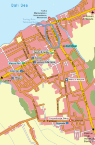
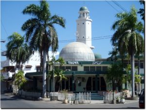
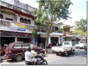
My first walk is just a little stroll out of Kampung Bugis past Masjid Taqwa down Jalan Diponegoro (Singaraja’s central business district – that’s probably too grand a title for Jalan Diponegoro, but I like it so why not) then over to Jalan A. Yani and back down Jalan Imam Bonjol to the harbor and home again. The route is traced out on the map of Singaraja for readers who want to locate the areas that I’m writing about on a map. Jalan Diponegoro is the central shopping area and the city’s main traditional market is located right in the middle of the street although it can be a bit difficult to discover because the entrance is just a small opening on Jalan Diponegoro – the actual market is between Diponegoro and Jalan Imam Bonjol. The market has fresh fruits and vegetables, meat, spices, clothes and a variety of other dry goods. Really, I don’t find it all that interesting, although it does seem to attract a number of tourists who want to see a traditional market.

The street also has electronic stores (I buy all my electronic equipment there), a few small restaurants, shoe stores, a few book stores (including a new one that I just discovered on this walk), a pharmacy, a few doctor’s offices, some fishing equipment shops, a small mini-market, two or three clothing stores, the main branch of BII (Bank Internasional Indonesia), a few hair saloons, a few gold shops, and an assortment of shops selling household goods. The street is almost always crowded with traffic due to the relatively new practice of allowing double parking which causes traffic to back up during the busy shopping hours of the day. I’ll get back to discussing Jalan A. Yani in another post.

imambonjol

Jalan Imam Bonjol is another busy street just to the east of Jalan Diponegoro. It is filled with shops selling a variety of things, such as household goods, furniture, car and motorbike parts, gold jewelry, and children’s toys. This street also has an entrance to the main market and a new mini-market. While Jalan Diponegoro is a one way street running north, Jalan Imam Bonjol is a one-way street running south. Most of the buildings are two stories with a shop on the ground floor and a residence on the second story. Running off of Jalan Imam Bonjol to the east and west are several small streets called gangs in Bahasa Indonesia.

Walking Tour of Singaraja, Bali: Jalan Erlangga and Jalan Hasanuddin

Today I’m going to walk up Jalan Hasanuddin which is just a street to the east of Jalan Imam Bonjol.
A map of my walks.

After leaving Kampung Bugis walking to the east comes the intersection of Jalan Diponegoro and Jalan Erlangga. Actually, Jalan Dipongegoro becomes Jalan Erlangga in that way that streets do here. Navigating any city in Bali is made more difficult by the fact that house and shop numbers do not necessarily change sequentially and one street suddenly becomes another without warning. Detailed maps may be of some help, but how many of us carry maps around with us? So out onto Jalan Erlangga; this is a short street. This part of it is narrow and often congested because of traffic coming from Jalan Diponegoro, which, as one of the main streets of Singaraja, gets a lot of traffic, and Jalan Pattimura which runs through Kampung Bugis and gets a lot of traffic because all of the trucks coming from the west have to be routed through Jalan Pattimura. Find a photo. A lot of cars and delivery trucks double park here which adds to the congestion.

Jalan Erlangga has a large furniture shop where we buy most of our furniture. We’ll occasionally run into foreigners from the Lovina area shopping for furniture there. This is not the expensive custom made furniture, but they have some nice beds and a few other pieces. One the south side of Erlangga is another furniture shop. We buy things there occasionally. Additionally, there are several automotive parts stores, a fishing/photography shop, a small grocery store selling dry goods and beverages, a baby shop and at several bicycle stores. Other buildings include a mosque and a store selling generators, hardware and other building tools.

Jalan Hasanuddin, Singarja Bali

Jalan Erlangga continues on past the intersection with Jalan Imam Bonjol. Here, Jalan Erlangga becomes a wider two-way street. Both sides have a number of shops selling building supplies such as paint, plywood, ceramic tiles, tools, varnish, nails and bolts, cement, and a variety of other building materials. This section of Jalan Erlangga continues on about 200 meters until it reaches the entrance to the old harbor and the bridge; it then becomes Jalan Surapati. Right across from the entrance to the bridge on the south side of the street is the start of Jalan Hasanuddin. Like Jalan Imam Bonjol, Jalan Hasanuddin is a one-way street running south. A lot of the buildings on Jalan Hasanuddin are storage facilities for local businesses. There is a busy pharmacy, a dentist’s office and a pediatrician’s office close by. Going south a ways is a pet supply store. No pets, just supplies like cages, aquariums, food for any number of creatures, and cigarettes. Yes, this pet store sell cigarettes.

Jalan Hasanuddin continues on south until it curves to the west and joins up with Jalan Imam Bonjol. As I walked this short stretch, I could hear the screams and laughter of children. I looked up and noticed an elementary school. I expected that because of the noise level the kids would be out on recess, but they were safely tucked away inside the classrooms. A large bathroom and tile store sits right at the intersection of Hasanuddin and Imam Bonjol. We’ve bought a few faucets and a toilet from them. They have a small, but interesting selection of bathroom fixtures, including a large solar water heater. This kind of store wasn’t around in Singaraja when we were building each of our houses. To get Western-type building supplies, we had to go down to Denpasar, and even there, the selection was limited. Singaraja has become more Western friendly in terms of construction materials, and, even Indonesians are now buying Western-type furnishings for their homes. Recently we visited a neighbor’s house and were surprised to see that they had a Western toilet in their bathroom along with a fancy sink and cabinet set. Across the street is a fairly large building supply store that sells paint, wood, plastic piping and so on.

And just where Jalan Imam Bonjol ends and splits into two streets, Jalan Gajah Mada starts and leads south to Denpasar. Jalan Dr. Sutomo splits off to the west for a short distance and becomes Jalan A. Yani which heads off to Lovina. Right at this busy intersection (noticeable for the large statute that marks the intersection), Singaraja’s post office is located. Generally the post office isn’t too busy, and it now has a small ATM in the parking lot.

I follow Jalan Dr. Sutomo – it only runs about 150 meters at the most – over to Jalan Diponegoro. Jalan Dr. Sutomo has a mix of small businesses that sell books, household goods and electronics. There is also a small internet shop that I used a few times when my internet connection was out. Perhaps most importantly, Bank Central Asia is here just across from the south entrance to Singaraja’s main market. BCA has an ATM machine and inside it’s possible to change currency including traveler checks. A police post, a clothing store and a motorcyle store are also located here.